

History · Chapter 10 of 10
Aranattukara Today
Ponds, paddy and bamboo gave way to roads and houses, and a market village became a ward of Thrissur city. What has changed, who has spoken for Aranattukara, and what is still worth keeping.
Anyone who grew up in Aranattukara before the 1980s can tell you how much it has changed. Joy Chiramel’s book is full of these memories: the croak of yellow frogs in the monsoon fields, washerwomen spreading white cloth on red laterite, families watching the sunset from the sand at the kadavu (boat landing). This last chapter looks at what has changed in the land, how Aranattukara became part of a city, and what remains.
A land of water
The old village was almost half ringed by water. Low paddy fields with never-failing channels kept its springs and wells full even in the hardest summer. Public ponds dotted the land. The Pachakkulam, the Kakkanamkulam, the temple pond and the pond by the kadavu are still there today. Most fields grew two crops of paddy a year. The dry land, once thick with bamboo and thorn, was cleared for coconut, areca, pepper, mango and jackfruit. Tradition says the Prior mango came from a tree planted at the Elthuruth Ashram in the time of St. Kuriakose Elias Chavara.
Every monsoon the water rose. Lalur Road and Convent Road ran like streams, and grown-ups walked schoolchildren across by the hand. The book recalls that people were sometimes swept away. It also recalls a great flood and storm, given in the English translation as 1899, that brought down many old mango and jack trees. In Kerala “the flood of ‘99” usually means the Malayalam year 1099, that is 1924, so that is probably the flood meant.
When the rains ended, the fields were ploughed and planted. Water was first lifted by a treadwheel, later by diesel pumps and then electric motors. In summer boys played ball on the cracked, dry fields, and people gathered water-lily pods and caught fish and eels in the shrinking channels.

How the water world ended
The kadavu lost its trade when the railway came and the canal was extended towards Kokkala for it. Cargo moved to Vanchikkulam and then to the rails. The landing silted into a sandbank, then a sand-mining site, then mud. A bridge over the boat canal turned the old water route to Vadookkara into a road. Large parts of the kol (low-lying wetland paddy) have been filled in and divided into plots. The landing steps of the old Tharakan houses are cut off from the water. All that is left of the kadavu is a walled public bathing pond, now kept by the Thrissur Corporation.

The greenery has thinned in the same way. As houses multiplied, the bamboo groves and old trees went. The book notes that the kavus (sacred groves) that once stood in many places now survive only in place names.
PLANT and the green corner at Lalur
One place has kept its trees. John Mathai filled his bungalow grounds at Lalur with rare trees, some brought from Ceylon and Malaysia. The book says the Dr John Matthai Centre is now the one place in Thrissur city where you can still hear the bamboo sing in the wind.
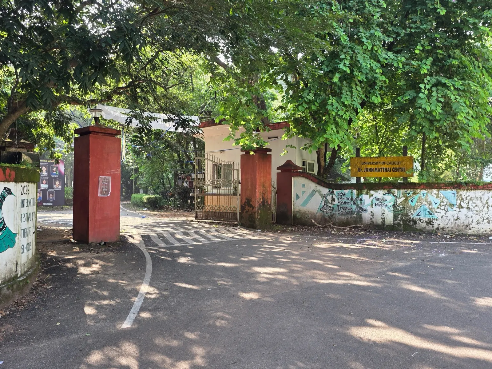
On World Environment Day, 5 June 2000, residents started PLANT (Protect Leaf and Add Nature in Tropics), with Dr D.P. Nair as president and Babu Jose Haritham as secretary. Its members planted saplings around Aranattukara. One of them, David Master, used a catapult to scatter tree seeds along riverbanks and cleared hillsides on his travels. They also numbered the rare trees at the John Matthai Centre and made a botanical guide that students still use. Today T.D. Paul leads PLANT and goes on planting where trees have been lost.
From village to city ward
The old revenue village of Aranattukara covered the desams (localities) of Aranattukara, Lalur, Karyattukara and Olari. Over the twentieth century it came into Thrissur piece by piece. Parts lay inside the municipality and parts in the Ayyanthole panchayat. According to the book, the first councillor from Aranattukara was Poothokkaran Rappayi of Valiyangadi, the Burmah Shell agent, who was nominated to represent the traders. In 1962 Therattil J. Antony and Thazhath J. Antony were elected, and both served for many years. Therattil J. Antony became chairman of the municipality.
In 2000 the municipality was joined with the Vilvattom, Ayyanthole, Koorkkenchery, Ollukkara and Ollur panchayats and parts of Nadathara to form the Thrissur Corporation. Its first Mayor was Jose Kattukkaran of Aranattukara. Aranattukara is now a ward of the city.
The book also lists the people who have represented Aranattukara over the years. In the municipal council they included T.P. Yohannan, C.P. Mary, C.J. Varunni, Surendran, Chacko Poothokkaran, Lissy Anto Tharakan, Francis Therattil, U.J. Thomas, Lali James, Prof. Sudhakaran, T. Radha, Francis Chalissery and Princy Raju. In the Ayyanthole panchayat there were C.P. Jose, Prof. Sudhakaran, Damodaran, T.K. Vasu, Lucy and John Kunjappu. In the Corporation there have been Lali James, Francis Chalissery, Reena Joy, Princy Raju, Sukumaran, P.K. Shajan, Saramma Robson and Anoop Davis Kada. The full list, with election years and wards, is on the councillors page; for today’s wards, boundaries and neighbouring areas, see Aranattukara at a glance.
What remains, and what is changing
A walk through Aranattukara today still passes the markers of every chapter in this series. The church and chapels and the Lalur temples are still there, and so are the Tharakan’s School and the old markets of Valiyangadi and Padinjare Angadi. The ponds are still there, the bakeries still bake, and the Aranattukara Kuries chit fund is more than a century old. At Lalur, where the city once dumped its rubbish, a new plant stands and the old plastic buried in the ground is still being processed.
Other things are fading. The kol fields are shrinking, the old tiled houses are coming down, and the landing that once made Aranattukara a port is now only a pond behind a wall. Many of the people who remember the boats, the bullock carts and the lamplighter are now very old.
Help us tell the rest
This history is a first draft. It leans on one book and on the memories of the people who helped write it, and it is strongest on the parish and the markets. There is much more to tell: the temples and the colony at Lalur, the workers’ families, the women who ran homes and shops, and the newer residents who have made Aranattukara home.
If you have an old photograph, a letter, a programme from a play, a story your grandmother told, or a correction, please share it with us. The next chapter of Aranattukara’s story will be written by the people who live it.
Sources
- Joy Chiramel, Arranadu – Aranadu – Orunadu (2024), ch. 1 (the desams of Aranattukara village)
- Joy Chiramel, Arranadu – Aranadu – Orunadu (2024), ch. 12 (ecological changes; PLANT)
- Joy Chiramel, Arranadu – Aranadu – Orunadu (2024), ch. 14
- Joy Chiramel, Arranadu – Aranadu – Orunadu (2024), ch. 16 (the people’s representatives)
Places and people in this story

Dr John Matthai Centre, Lalur
The University of Calicut campus at Lalur, on the green estate where John Mathai lived, home to the Department of Economics and the School of Drama.

The Lalur Trenching Ground
The land at Lalur where Thrissur dumped its waste for decades, and where residents fought a long campaign until the dumping stopped.

Elthuruth Ashram
The Carmelite monastery founded in 1858 by St. Kuriakose Elias Chavara on an islet at the western edge of Aranattukara parish.

John Mathai
Economist and India's first Railway Minister, later Finance Minister, who made his home at Lalur in Aranattukara.

Therattil J. Antony
Aranattukara's long-serving Congress councillor and Thrissur municipal chairman, remembered as Anthonichettan.

Jose Kattukkaran
Congress leader from Aranattukara who became the first Mayor of Thrissur Corporation in 2000.